Visitors to Three Falls Cove
Countless generations of people have visited this sheltering valley. Some camped here for a short time, but others called the Bugbee Creek valley ‘home.’ Each culture had its own way of using the valley’s precious resources, and each left their imprint in the soil.
With its pure water and abundant plant and animal life, it is not surprising that prehistoric sites occur in the Bugbee Creek valley. The earliest camping place that we know of was home to hunting and gathering Archaic peoples several thousands of years ago. Burned quartzite rocks from their fires line the creek bank.
 At Three Falls Cove, the camping place
was above the spring, on the highest point on the landscape. [If you go to the crosses and walk straight up the hill, you can see the burned rocks. Please leave
them in place]. The Archaic people had easy access to water, but animals could also use the springs. Being high above the creek, they were also out of the range of many
insects, and they had a good view of their surroundings.
 Downslope
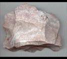
from the camp, archaeologists found a large piece of
Alibates flint that may be from the camp. Its edges are
roughly worked into the shape of a cutting tool, but it
was abandoned before completion. The tool-maker had
brought a large piece of flint to this spot to work on.
We know it was brought here because there are no
exposures of flint at Three Falls Cove. There are good
nodules of quartzite, useful for hearth stones, hammer
stones, and some tools, but no flint.
 The creek also provided home sites for people belonging to what we call the Antelope Creek culture (A.D.1150-1450). Antelope Creek people hunted buffalo on the High Plains and grew corn and other plants in the river valley. The buffalo was their mainstay. Its meat was food; hides, sinew, and guts made clothes, lashings, and vessels; its bones became tools. One distinctive tool was the hoe made of the bison scapula (shoulder bone) which was used to plant and tend the corn.
Most houses were used by single families. They lived in one room that was partly dug below ground and partly above ground. The walls were lined with dolomite slabs on the lower part and made of stacked cobbles and chunks of dolomite on the upper part. These were snug little houses. Sleeping benches lined the inner walls. Sweet-smelling grasses and fur blankets probably covered the benches. A hearth in the center of the room was used for warmth and cooking. As you sleep here, imagine an Antelope Creek family, also settled comfortably for the night.
Toward the end of their time, the Antelope Creek people banded into larger groups. Their hamlets of apartment-like dwellings were built in valleys of this area, and two large villages of perhaps 50 houses each are located on Alibates Creek across the Canadian River from Bugbee Creek. One possible reason for banding together was to improve the process of quarrying, working and exporting flint. Quantities of Alibates flint are found in villages of the same time period in the Texas Panhandle, Oklahoma, New Mexico, and Colorado. Individual pieces of Alibates flint from earlier time periods have been found as far away as Wyoming.
Massive quantities of flint were quarried from pits atop a large mesa on the other side of the Canadian River. The 700+ pits attest to the use of this quarry as “Texas’ First Industrial Site.” The villages are not open for visitation, but Park Rangers lead guided tours of the flint quarries throughout the summer.
After A.D. 1450, the Antelope Creek dwellings were abandoned. It is possible that the residents left the Texas Panhandle and joined relatives elsewhere on the Great Plains. When Coronado came through the Panhandle in 1541, he saw only empty villages. The few native peoples he met lived primarily by hunting bison.
We know little about the hunters who lived along Bugbee Creek from the time of Coronado to the 1700s. Perhaps their camps were close to the river and are now covered by Lake Meredith. These people may be ancestral to Plains tribes such as the Wichita and Comanche
In the mid- to- late 1800s, important trade routes crossed the Panhandle. Marcy’s Road ran east-west from Fort Smith into Santa Fe. A large part of this route ran along the Canadian River. Another trade route, the Gregg Trail, also ran through the Panhandle. A portion of Gregg’s 1840s trail can be seen on tours at the Wildcat Bluff Nature Center in northwest Amarillo.
Following the trade routes east from Santa Fe, Hispanic sheepherders entered this area looking for good pasture. Along with Comancheros, they were also middlemen for the buffalo trade. By 1880, there were hundreds of these sheepherders, called pastores, and over 100,000 animals. Pastores lived either in individual houses or in small villages built of stacked stones, much like the Antelope Creek people 500 years earlier. The village had a plaza, houses, and communal buildings. Animal pens surrounded the villages.
While we do not have
pastores dwellings here on Bugbee Creek, we do know that
they used the creek
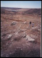 mouth
for sheep pens. They built low walls of stone
across the mouth of the creek and up the sides of the
valley. The main portion of the wall is probably
covered by Lake Meredith.
Eventually, the pastores moved back into New Mexico. Before the Red River Indian Wars of 1874-75, they had problems with the native peoples; after the war, they had problems with the cattleman and with the diminishing trade in bison.
Cattlemen were not fond of either sheep or buffalo. The vast grasslands on the High Plains could be used to graze cows which could be sold to the reservations set up to house the native Americans, or shipped north for processing. This was a huge, and highly profitable, business.
One of the first cattlemen in the area was Thomas G. Bugbee, who in 1877 set up the Quarter Circle J Ranch right here on Bugbee Creek.


